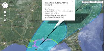
TS Karen forms in Gulf
One way or another, Louisiana is most likely looking at a wet weekend. The question is, what will cause that rain, a cold front or a tropical storm.
Early Thursday morning Tropical Storm Karen formed in the Gulf of Mexico with computer models sending the storm as far west as central Louisiana and as far east as Florida’s east coast.
In response, a hurricane watch was put into place on the Gulf Coast from Grand Isle to Indian Pass, Fla. Tropical storm watches surround those areas, particularly to the west.
Karen is expected to make landfall as a tropical storm this weekend, but uncertainty as to where the storm will come in and how strong it will be when it hits the coast remains.
That uncertainty, in part, comes from a cold front moving straight for Louisiana. That system could push Karen more to the east and away from the state.
As of late Thursday, the front was expected to arrive in Louisiana between Saturday afternoon and Sunday afternoon. If it arrives in time, it could push the storm east and the faster the front moves, the more east the storm will be pushed.
It is important to remember, according to meteorologists, that with a storm like this, anything can happen.
And, bottom line, the combination of the storm system and the cold front is expected to bring a good amount of rain to south Louisiana, along with rough coastal waters and above average tides.
The good news for many is that the cold front will give the state its first feel of fall with lows Sunday night projected to be in the mid-50s in the area.
- Log in to post comments
